

Hong Kong September 2026 Rainfall: Polymarket Odds, HKO Outlook & PredictBoy Analysis
I’m PredictBoy, and this market is a good example of why weather prediction markets need more than a single forecast screenshot. The contract resolves on the final monthly rainfall total at the Hong Kong Observatory, so the key question is not “Will it rain this week?” but “Which bracket contains the finalized September 1–30 total?”
Evidence labels: verified facts come from Polymarket or the Hong Kong Observatory; market-implied probabilities are the displayed Polymarket percentages; analytical assumptions are my weighted scores; and PredictBoy probabilities are my own normalized assessment. Market prices are not guaranteed real-world probabilities, and this article is analytical information, not financial advice.
What This Polymarket Market Asks
Verified fact: the Polymarket event resolves according to the total precipitation in Hong Kong from September 1 through September 30, 2026, as reported by the Hong Kong Observatory.
The ten brackets are:
- <275 mm
- 275–300 mm
- 300–325 mm
- 325–350 mm
- 350–375 mm
- 375–400 mm
- 400–450 mm
- 450–500 mm
- 500–550 mm
- 550 mm+
The bracket geometry matters. The first bucket is open-ended on the low side, while most middle buckets are only 25 or 50 mm wide. That alone gives <275 mm a structural probability advantage when the outlook leans dry.
Resolution Rules and What Counts
- Measurement: total rainfall in millimetres from September 1–30, 2026.
- Primary source: Hong Kong Observatory, specifically the finalized “Total Rainfall (mm)” figure in the September 2026 Daily Extract.
- Boundary rule: if the finalized value lands exactly on a bracket boundary, the market resolves to the higher bracket. So 275.0 mm belongs to 275–300 mm, 300.0 mm belongs to 300–325 mm, and so on.
- Resolution precision: 0.1 mm.
- Fallback: if the relevant HKO data is not available by December 7, 2026 at 11:59 PM ET, Polymarket says another credible resolution source will be chosen.
- Revisions: revisions made after the data is finalized for this market’s timeframe are not considered.
- Displayed event end date: October 1, 2026.
- Market opened: August 31, 2026 at 9:41 AM ET.
Current Market Snapshot
At 2026-09-04 21:40 UTC, Polymarket displayed $7,094 in event volume. The market was still extremely young and thin: the <275 mm contract alone showed roughly $5,574 of volume, while most other brackets showed only about $154–$195 each. No single reliable event-level liquidity figure was exposed in the captured page, so I do not invent one.
| Bracket | Displayed probability | Buy Yes | Buy No | Outcome volume |
|---|---|---|---|---|
| <275mm | 53% | 57¢ | 50¢ | $5,574 |
| 275-300mm | 14% | 14¢ | 87¢ | $155 |
| 300-325mm | 12% | 13¢ | 89¢ | $155 |
| 325-350mm | 9% | 11¢ | 93¢ | $176 |
| 350-375mm | 5% | 8.7¢ | 99¢ | $155 |
| 375-400mm | 5% | 7.9¢ | 98.9¢ | $154 |
| 400-450mm | 2% | 11¢ | — | $180 |
| 450-500mm | 1% | 2¢ | 99.8¢ | $195 |
| 500-550mm | 4% | 7.1¢ | 99.6¢ | $176 |
| 550mm+ | 7% | 8.9¢ | 95¢ | $177 |
Important: these bracket percentages come from separate binary markets, bid/ask spreads, and a thin new order book. They sum to more than 100% in the captured snapshot, so they should not be treated as one normalized probability distribution.
Main Outcomes
<275 mm — Market Favorite
Market-implied: 53% displayed. Verified climate context: HKO’s September 2026 monthly forecast says the chance of normal to below-normal rainfall is slightly higher. Because the <275 mm bucket captures every final total from 0.0 to 274.9 mm, it benefits more from a dry bias than any one narrow middle bucket.
275–325 mm — Near-Normal Core
HKO’s 1991–2020 climatological normal for September rainfall is 321.4 mm. That puts the 300–325 mm bracket directly around the long-run mean and makes 275–300 mm another plausible near-normal outcome. My weighted framework actually gives 300–325 mm the highest “point-fit” score, even though <275 mm remains the single most likely bracket in my probability distribution.
325–400 mm — Moderately Wet September
This zone requires either more persistent shower activity or one or more stronger rain episodes, but not necessarily an extreme tropical cyclone impact. HKO’s first-half outlook keeps this region live because broad troughs of low pressure are expected over the central and northern South China Sea.
400–550 mm — Wet-Month Tail
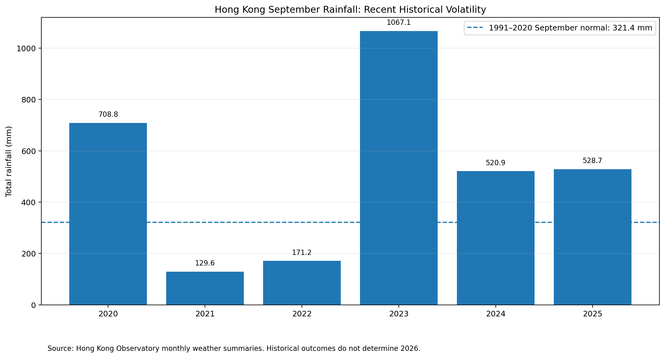
This range becomes more likely if a low-pressure system, tropical cyclone, or prolonged trough affects Hong Kong directly. Recent history shows that wet September totals are not unusual: 2024 reached 520.9 mm and 2025 reached 528.7 mm.
550 mm+ — Extreme Tail
The 550 mm+ bucket is a genuine tail, not a fantasy. HKO recorded 708.8 mm in September 2020 and a record 1,067.1 mm in September 2023. The route is usually not “many slightly wet days”; it is one or more major tropical-cyclone or trough-driven events.
Key Factors
The five factors below are designed specifically for a monthly rainfall bracket market. I give the most weight to HKO’s official monthly outlook and climatological fit, while preserving a large weight for tropical-cyclone tail risk because Hong Kong’s September rainfall distribution is highly skewed.
Weighted Outcome Comparison
Analytical assumption: these are 0–10 structural fit scores, not probabilities. They are not tuned to match Polymarket.
| Factor | Weight | <275mm | 275-300mm | 300-325mm | 325-350mm | 350-375mm | 375-400mm | 400-450mm | 450-500mm | 500-550mm | 550mm+ | Key Evidence | Impact |
|---|---|---|---|---|---|---|---|---|---|---|---|---|---|
| HKO September rainfall outlook | 30% | 9.5 | 9.0 | 8.5 | 7.0 | 6.0 | 5.0 | 4.0 | 3.0 | 2.5 | 2.0 | HKO’s September 2026 monthly forecast slightly favors normal to below-normal rainfall. | High |
| Climatological fit vs 321.4 mm normal | 25% | 7.0 | 8.0 | 10.0 | 9.0 | 7.5 | 6.5 | 5.5 | 4.5 | 3.5 | 2.5 | 1991–2020 September normal is 321.4 mm; 300–325 mm is closest to the long-run mean. | High |
| Early-month / near-term weather signal | 15% | 9.0 | 8.5 | 8.0 | 7.5 | 6.5 | 5.5 | 5.0 | 4.5 | 4.0 | 3.5 | Saudel weakened; near-term HKO outlook calls for only isolated/few showers before a finer spell. | Medium |
| Tropical-cyclone / extreme-rain tail risk | 20% | 5.0 | 5.5 | 6.0 | 6.5 | 7.0 | 7.5 | 8.0 | 8.5 | 9.0 | 10.0 | Hong Kong’s September rainfall has a heavy right tail because one tropical cyclone or trough can add hundreds of millimetres. | High |
| Second-half anticyclone / seasonal drying | 10% | 9.5 | 9.0 | 8.0 | 7.0 | 6.0 | 5.0 | 4.0 | 3.0 | 2.5 | 2.0 | HKO expects an anticyclone aloft to strengthen in the latter half of September. | Medium |
| Weighted total | 100% | 7.90 | 7.97 | 8.25 | 7.48 | 6.65 | 5.95 | 5.33 | 4.70 | 4.28 | 3.95 | Consistent 0–10 analytical scoring. | — |
The weighted model puts 300–325 mm first at 8.25/10 because it is closest to the 321.4 mm climatological normal. But that does not</em make it the highest-probability contract: it is only 25 mm wide. The open-ended <275 mm bucket has more room to win if the month finishes materially dry, and HKO’s official monthly outlook provides a modest dry tilt.
Topic-Specific Evidence Analysis
HKO’s official September outlook leans dry, but only slightly
The Hong Kong Observatory monthly forecast for September 2026 expects normal to above-normal temperature and says the chance of normal to below-normal rainfall is slightly higher. This supports the market’s low-rainfall favorite, but “slightly higher” is not the same as a 50%+ guarantee for one specific bracket.
The month has two competing weather regimes
HKO expects broad troughs of low pressure to create unsettled conditions over the central and northern South China Sea in the first half of September, favoring low-pressure areas and tropical cyclones. In the latter half, an anticyclone aloft is expected to strengthen. That creates a natural “storm risk early, drying bias later” structure.
Saudel did not turn the opening week into a washout
Saudel weakened into an area of low pressure over inland Guangdong by September 4, and HKO cancelled all tropical-cyclone signals. The September 5 local outlook called for mainly cloudy conditions, sunny periods, and isolated showers later, followed by a few showers on Sunday and a generally finer spell after that. The 9-day outlook nevertheless warned that another broad low-pressure area could develop over the central South China Sea later the following week.
Recent September rainfall is extremely volatile
Official HKO monthly totals were 708.8 mm in 2020, 129.6 mm in 2021, 171.2 mm in 2022, 1,067.1 mm in 2023, 520.9 mm in 2024, and 528.7 mm in 2025. That range is the central risk in this market: seasonal guidance can lean dry while a single tropical system still pushes the month into a high bucket.
What the Market May Be Underestimating
The middle: the market’s 53% displayed number for <275 mm looks aggressive for a market with only a few days of trading and very thin liquidity outside the leader. My normalized distribution gives more combined probability to 275–450 mm than the raw screen impression suggests.
The tail: 400 mm+ outcomes look small individually, but Hong Kong’s recent September history is dominated by high-rainfall years. A direct tropical-cyclone or trough event can jump several brackets quickly, so I would not collapse the entire wet tail to near zero.
Bull/Bear Case for Major Outcomes
| Range | Bull Case | Bear Case |
|---|---|---|
| <275 mm | HKO leans normal-to-below; near-term weather is not immediately extreme; second-half anticyclone favors drying. | A first-half tropical cyclone or prolonged trough can erase the dry thesis in a few days. |
| 275–325 mm | Closest to the 321.4 mm normal and consistent with a broadly near-normal month. | Narrow brackets make them vulnerable to even modest forecast error. |
| 325–400 mm | One meaningful wet spell plus otherwise normal weather can land here. | Dry second half or no direct cyclone impact pushes the month below this zone. |
| 400–550 mm | Recent 2024 and 2025 totals show this range is entirely plausible. | Needs a more persistent or intense rain event than current near-term guidance shows. |
| 550 mm+ | Historical extreme years demonstrate large upside from tropical systems. | Requires a genuine high-impact event; HKO’s monthly outlook currently leans the other way. |
Risks and Uncertainties
- Track risk: tropical-cyclone rainfall depends heavily on track, speed, size, and rainband placement.
- Timing risk: a storm late in the month can overturn a strong early signal.
- Thin-market pricing: many outcome books are lightly traded, so displayed percentages may be noisy.
- Seasonal forecast limits: HKO itself notes that climate forecasts carry substantial uncertainty and different models can disagree.
- Resolution-data timing: the market waits for finalized HKO data; I do not substitute provisional station totals for the official resolution figure.
- Bracket boundary risk: exact boundary values resolve upward, which matters around 275.0, 300.0, 325.0 mm, and the other thresholds.
PredictBoy Probability Assessment
PredictBoy interpretation — analysis, not fact:
| Bracket | PredictBoy Probability | Reason |
|---|---|---|
| <275mm | 38% | Open-ended low-rainfall bucket plus HKO’s dry-leaning monthly outlook. |
| 275-300mm | 16% | Near-normal but below the climatological mean. |
| 300-325mm | 14% | Best point-fit to the 321.4 mm normal, but only a 25 mm-wide bracket. |
| 325-350mm | 9% | Plausible near-normal range with less help from the dry outlook. |
| 350-375mm | 6% | Requires a somewhat wetter month without a major extreme event. |
| 375-400mm | 5% | Moderately wet scenario. |
| 400-450mm | 4% | Needs more persistent rain or a stronger tropical contribution. |
| 450-500mm | 3% | Wet-month tail. |
| 500-550mm | 2% | Very wet scenario; recent years prove it is possible. |
| 550mm+ | 3% | Extreme-rain tail driven mainly by tropical cyclones or major trough events. |
These probabilities total 100%. My base case is still <275 mm at 38%, but I am materially less confident than the market’s displayed 53% because the historical distribution has a heavy storm-driven right tail.
Market Odds vs. PredictBoy
| Bracket | Polymarket Displayed | PredictBoy | Difference |
|---|---|---|---|
| <275mm | 53% | 38% | -15.0 pts |
| 275-300mm | 14% | 16% | +2.0 pts |
| 300-325mm | 12% | 14% | +2.0 pts |
| 325-350mm | 9% | 9% | +0.0 pts |
| 350-375mm | 5% | 6% | +1.0 pts |
| 375-400mm | 5% | 5% | +0.0 pts |
| 400-450mm | 2% | 4% | +2.0 pts |
| 450-500mm | 1% | 3% | +2.0 pts |
| 500-550mm | 4% | 2% | -2.0 pts |
| 550mm+ | 7% | 3% | -4.0 pts |
The biggest disagreement is the leader: I take 15 percentage points off <275 mm and spread that probability across the 275–500 mm middle. I also keep 3% on 550 mm+ because recent HKO history shows extreme September totals can materialize abruptly.
What Could Change Before Resolution
- A new tropical cyclone entering the northern South China Sea with a track toward the Pearl River Delta.
- HKO upgrading significant-rain probabilities across several consecutive days.
- Repeated trough-driven heavy shower episodes in the first half of September.
- A stronger-than-expected anticyclone suppressing rainfall in the second half.
- Emergence of a reliable finalized or near-final HKO monthly accumulation that materially narrows the remaining possibilities.
Primary Factors
- Official HKO monthly rainfall outlook.
- Accumulated rainfall versus the 321.4 mm climate normal.
- Tropical-cyclone and trough activity.
Secondary Factors
- Near-term significant-rain forecasts.
- Strength and timing of the late-month anticyclone.
- ENSO and broader seasonal background.
Overall Probability Outlook
I see a dry-leaning distribution with a very asymmetric wet tail. The best “central-value” bracket is 300–325 mm, but the single most likely contract remains <275 mm because it is open-ended and the official monthly outlook leans toward normal-to-below rainfall.
Final Take
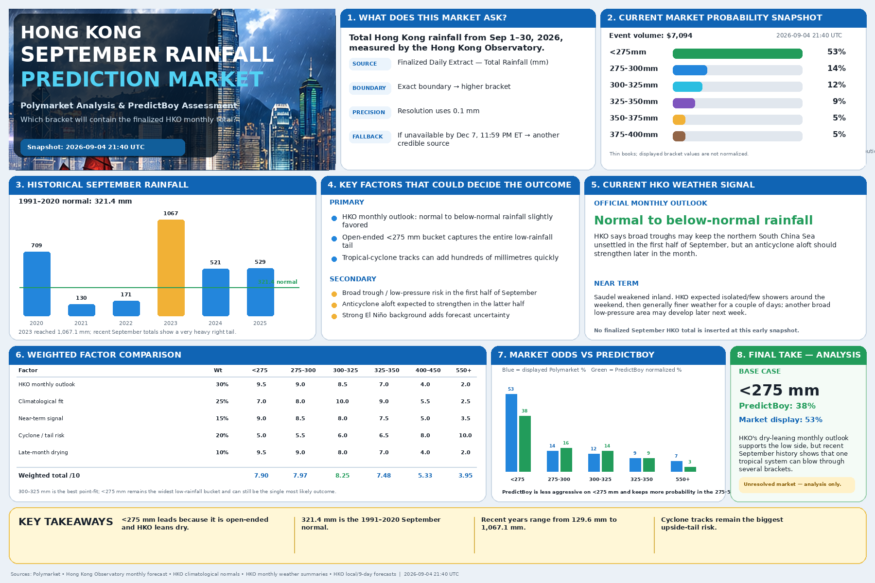
PredictBoy analysis: <275 mm is my base case at 38%, versus Polymarket’s 53% displayed snapshot. I agree with the direction of the market, but not the degree of confidence. Hong Kong’s September rainfall is too sensitive to tropical-cyclone tracks for me to put more than half of the distribution into the lowest bucket this early in the month.
The most important update to watch is not a single rainy afternoon. It is whether HKO starts showing a sustained heavy-rain setup or a tropical system with a track capable of adding 100–300+ mm in a short window. If that does not happen and the second-half anticyclone develops as expected, the low-rainfall brackets should strengthen.
Sources
- Polymarket — Precipitation in Hong Kong in September?
- Hong Kong Observatory — 1991–2020 climatological normals
- Hong Kong Observatory — Monthly Forecast for September 2026
- Hong Kong Observatory — Seasonal Forecast Sep–Nov 2026
- Hong Kong Observatory — Local Weather Forecast
- Hong Kong Observatory — 9-day Weather Forecast
- Hong Kong Observatory — Tropical Cyclone Position / Saudel
- HKO — September 2020 Monthly Weather Summary
- HKO — September 2021 Monthly Weather Summary
- HKO — September 2022 Monthly Weather Summary
- HKO — September 2023 Monthly Weather Summary
- HKO — September 2024 Monthly Weather Summary
- HKO — September 2025 Monthly Weather Summary
Disclosure: Weather and prediction-market probabilities can change rapidly. This article is for informational analysis only and is not financial advice.